Tropical Storm Gabrielle forms in Atlantic with possibility to strengthen further, National Hurricane Center says
Written by ABC Audio ALL RIGHTS RESERVED on September 17, 2025

(NEW YORK) — The Atlantic basin may have been quiet going into the peak of hurricane season, but officials are watching a new system that has developed into a tropical storm, which has the possibility of strengthening further.
The National Hurricane Center confirmed on Wednesday that Tropical Storm Gabrielle has formed in the Central Atlantic.
Te tropical storm does not pose a threat to the United States, as of Wednesday. The system should remain over open waters for several days, the NHC said.
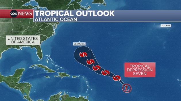
The system previously met the criteria to be designated a tropical depression with winds greater than 34 mph on Wednesday.
Although dry air and other unfavorable atmospheric conditions have recently hindered development, the storm is expected to move into a more favorable environment later this week, giving it a better chance to become organized.
The storm will move Northwest and is not expected to hit any of the Leeward Islands or the Caribbean. If it develops further, the storm could be a hurricane in the vicinity of Bermuda.
The storm, which was originally described as a disturbance, was expected to become a tropical depression or tropical storm by the end of the week as it churns northwestward across the central Atlantic Ocean.
The development of a new tropical cyclone would mark the end of a notably quiet period in the Atlantic Basin, a stretch that included the climatological peak of the hurricane season on Sept. 10.
Tropical activity is expected to gradually ramp up over the next few weeks as conditions become more favorable for development, forecasters say.
NOAA’s Climate Prediction Center said the odds of tropical development are increasing across parts of the Atlantic Basin for the second half of September, as large-scale environmental conditions become more favorable.
Tropical weather experts at Colorado State University (CSU) echo these predictions, saying overall atmospheric conditions, including wind patterns, will shift in a manner that supports a notable increase in activity.
While the climatological peak of the Atlantic hurricane season has passed, roughly 60% of tropical activity typically occurs after Sept. 10, on average, according to the National Hurricane Center.
The remainder of September and October will likely be active, David Zierden, the Florida state climatologist and head of the Florida Climate Center at Florida State University, told ABC News last week.
September and October often see some of the busiest activity for hurricanes because sea surface temperatures can be at their highest, Zierden said. Higher temperatures provide “ample fuel” for the formation and intensification of tropical cyclones, he added.
Waters in the Gulf and Caribbean are currently “very warm,” Jennifer Francis, an atmospheric scientist at the Woodwell Climate Research Center, told ABC News last week.
Historically speaking, about two-thirds of all Atlantic hurricane season activity occurs between Aug. 20 and Oct. 10. In August, NOAA predicted above-normal activity for the remainder of the Atlantic hurricane season.
Last year demonstrated that late September and early October can be an active period for tropical development, with multiple threats that may be high-impact and potentially devastating.
Hurricane Helene, which caused devastating flooding in North Carolina, formed on Sept. 24, 2024, while Hurricane Milton, which caused widespread destruction in Florida, formed on Oct. 5, 2024.
ABC News’ Kenton Gewecke and Kyle Reiman contributed to this report.
Copyright © 2025, ABC Audio. All rights reserved.


